Hutchinson Square is the town square of Summerville, South Carolina. We went looking for every dated photograph of it we could find and put them in order: 46 photographs, postcards, fire-insurance maps and plans, from a sand street with pines in it to the fountain, pavilion and arch that stand there now. Each one names its source and says how it was dated.
Which way is which
The railroad runs across the north end of the square and Town Hall closes the south end. Main Street runs down the east side; Little Main is the west side, in front of the brick shop row.
The name
No source before 1950 was found using “Hutchinson Square.” Period captions say “Main Street” and maps say “Park.” Most accounts credit Edward L. Hutchinson, the first intendant; Visit Summerville names Phillip Henry Hutchinson (1839–1910). No naming date was found.
The gaps
Three stretches have no photograph online: 1908 to the mid-1930s, 1948 to 1969, and 1980 to 2008. They are marked where they fall, and the end of the page lists who probably holds the pictures.
How the video was made
The video holds one view: north up the square from its south end. Only one frame in it is a real photograph, the Library of Congress view from about 1906, taken from the old Town Hall tower. Every other era is an AI reconstruction of that view, built from the dated photographs and maps for that period, and the motion between eras is AI-generated too. From 2014 the camera rises to a drone’s height, and those frames follow drone photographs of the square today.
The reconstructions are illustrations, not records. They follow the sources but invent detail, and should never be cited as photographs. The archive below is the evidence.
13 of the 46 items show their image here: the ones that are public domain, free to reuse, or published before 1929. The rest link to the original, since their owners reserve the rights.
1832 – c. 1900
The railroad’s wide street
The South Carolina Canal and Rail Road Company laid out “New Summerville” in 1832. Its plan made Main Street 200 feet wide, twice the width of every other street, and left open space for a town centre. For most of the century that space was a broad sand street with pines standing in it. No image from the 1870s turned up, and no 1886 earthquake photograph of the square or depot.
- 1880s
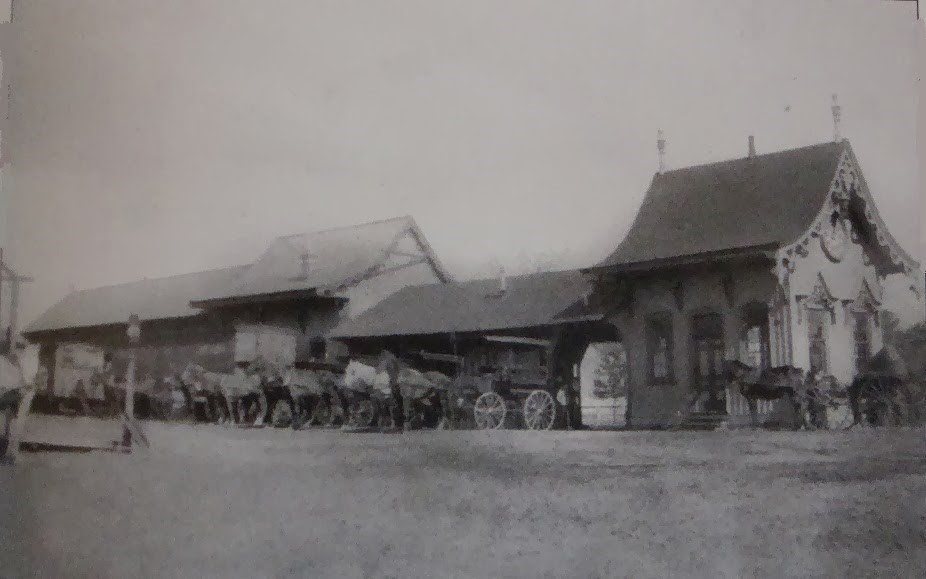
The Victorian depot, with carriages waiting
An ornate passenger building with gingerbread bargeboards, a long covered platform and freight shed, and a line of horse-drawn carriages meeting a train. This is the earlier depot. The 1895 map draws it among the tracks, on a different site from the station in every later view.
- 1880 – 1895
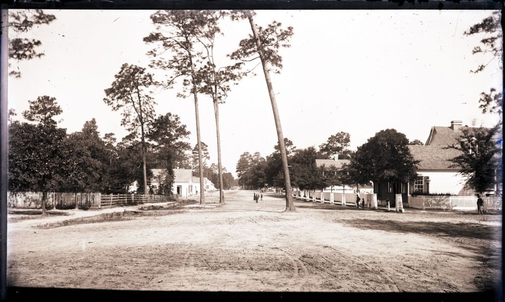
A wide sand street with pines down the middle
A very wide unpaved street, tall pines standing in the roadway, picket fences and houses on both sides. This is what the 200-foot Main Street would have looked like before the park was fenced.
Check Location unconfirmed. The archive titles it “Summerville? Residences and street” and does not name the street.
- December 1895
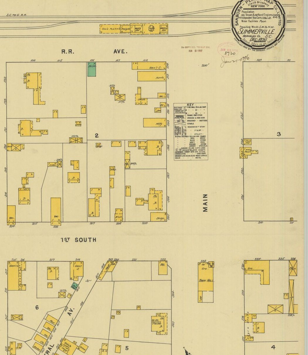
Fire-insurance map: a street, not yet a park
Main is drawn 200 feet wide with nothing in it. The depot (covered platform, freight room, waiting rooms, ticket office) sits on the tracks at the top. The three-storey Town Hall with its tower stands in the middle of Main at 1st South Street, with a grocery on the ground floor.
- c. 1895 – 1900
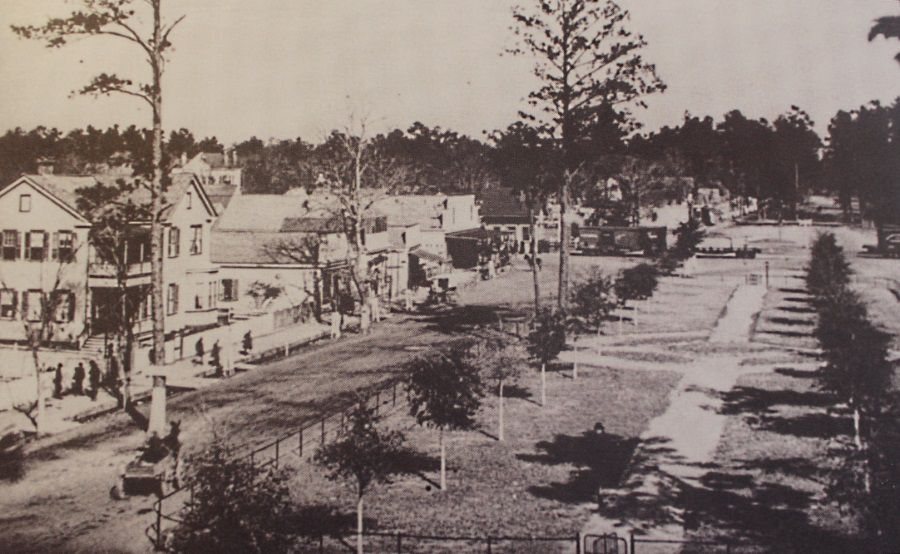
The new park, with staked saplings
The earliest view found of the fenced park: a straight central walk, small conical evergreens, saplings on stakes, wood-frame buildings where brick blocks stand by 1906, and railroad cars at the far end.
Check Date estimated, not documented.
1902 – 1920s
The fenced park
Between December 1895 and August 1902 the wide street became a bounded park, and a new Southern Railway station went up on the axis of Main Street at its north end. The square is best documented in 1906 and 1907, the height of the town’s resort trade, when four different views were made within about eighteen months. Every one is titled “Main Street.” Maps of the period label the space “Park.”
- April 1902
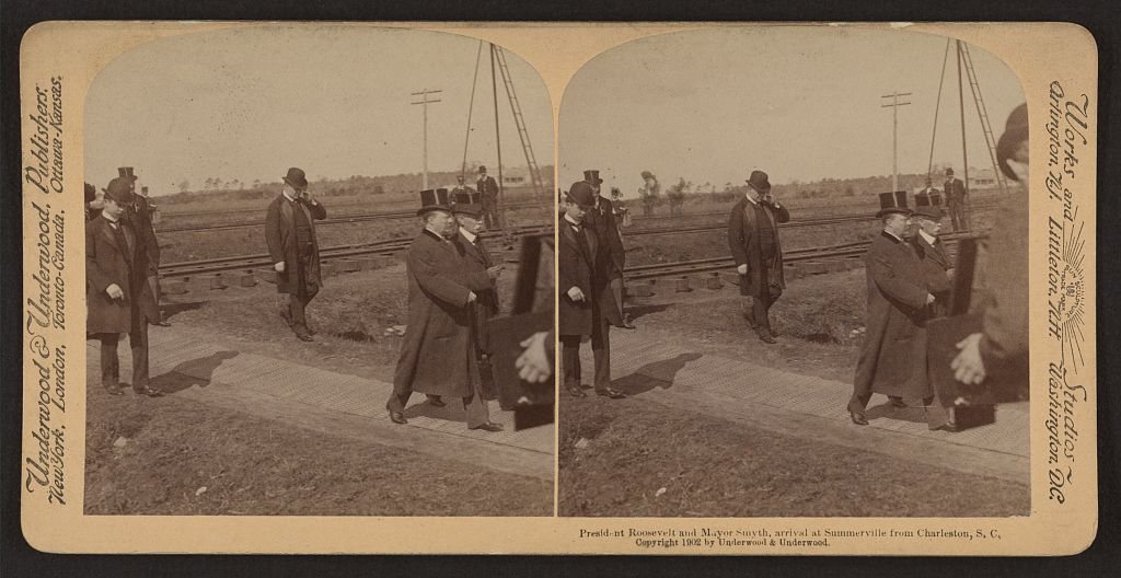
President Roosevelt arrives at Summerville
Theodore Roosevelt and Charleston mayor J. Adger Smyth, in top hats, walk a plank path away from the tracks. A stereograph sold as a souvenir of the visit.
Check Trackside at Summerville, but no depot, storefront or park is in frame, so it may not be at the head of the square.
- August 1902
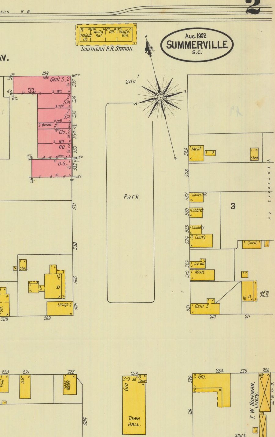
Fire-insurance map: the first “Park”
A rounded rectangle labelled “Park” now fills the middle of Main. The new “Southern R.R. Station” closes the north end and Town Hall the south. Brick buildings (pink) have replaced frame ones on the west side, including a post office and dry-goods store.
- c. 1906Key view
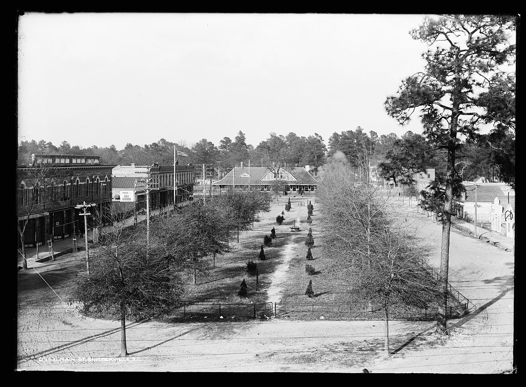
The whole square from the Town Hall tower
The single best early image. Looking north up the length of the park: a low fence with a gate, a straight central walk lined with young conifers, leafless young trees along the edges, sand streets on both sides. The brick commercial row with its “Dry Goods” sign and flagpole is at left, the hip-roofed station closes the far end.
- July 1906
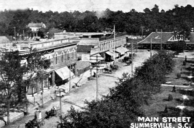
Postcard: the west side and the depot
A raised view from the south-west. Wagons and buggies stand at the kerb in front of the two-storey brick block, the park’s conifers are at lower right and the station at upper right.
- By March 1907
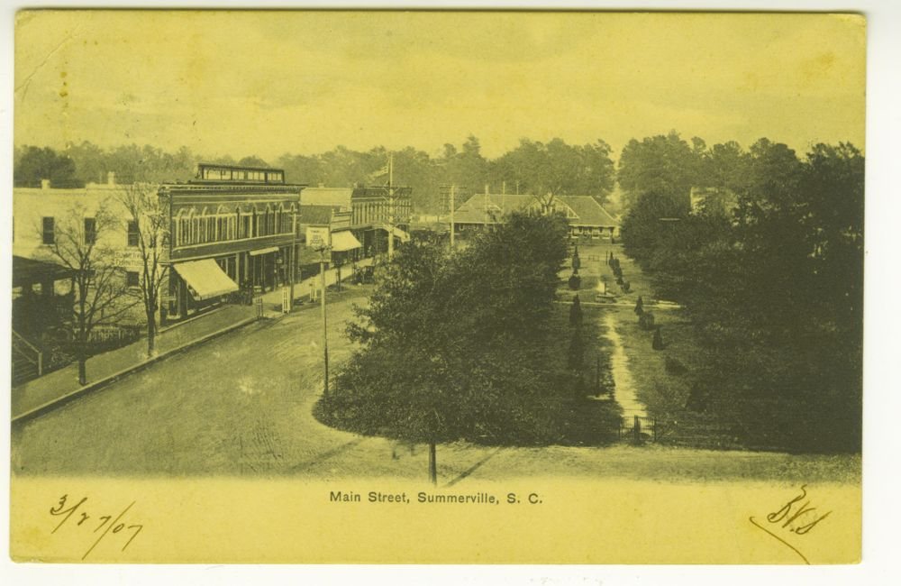
Postcard: the park in leaf
Nearly the same viewpoint as the 1906 photograph but a separate exposure, with the trees in full leaf. Published by Egan Studio of Summerville.
- By September 1907
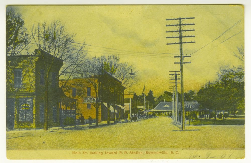
Colour postcard: “Main St. looking toward R.R. Station”
Street level, looking north along the west side. A “Summerville Furniture Co.” sign, the brick row with awnings and flagpole, tall telegraph poles, the edge of the park at right and the station in the distance. Hand-coloured.
- Before c. 1910 – 1920
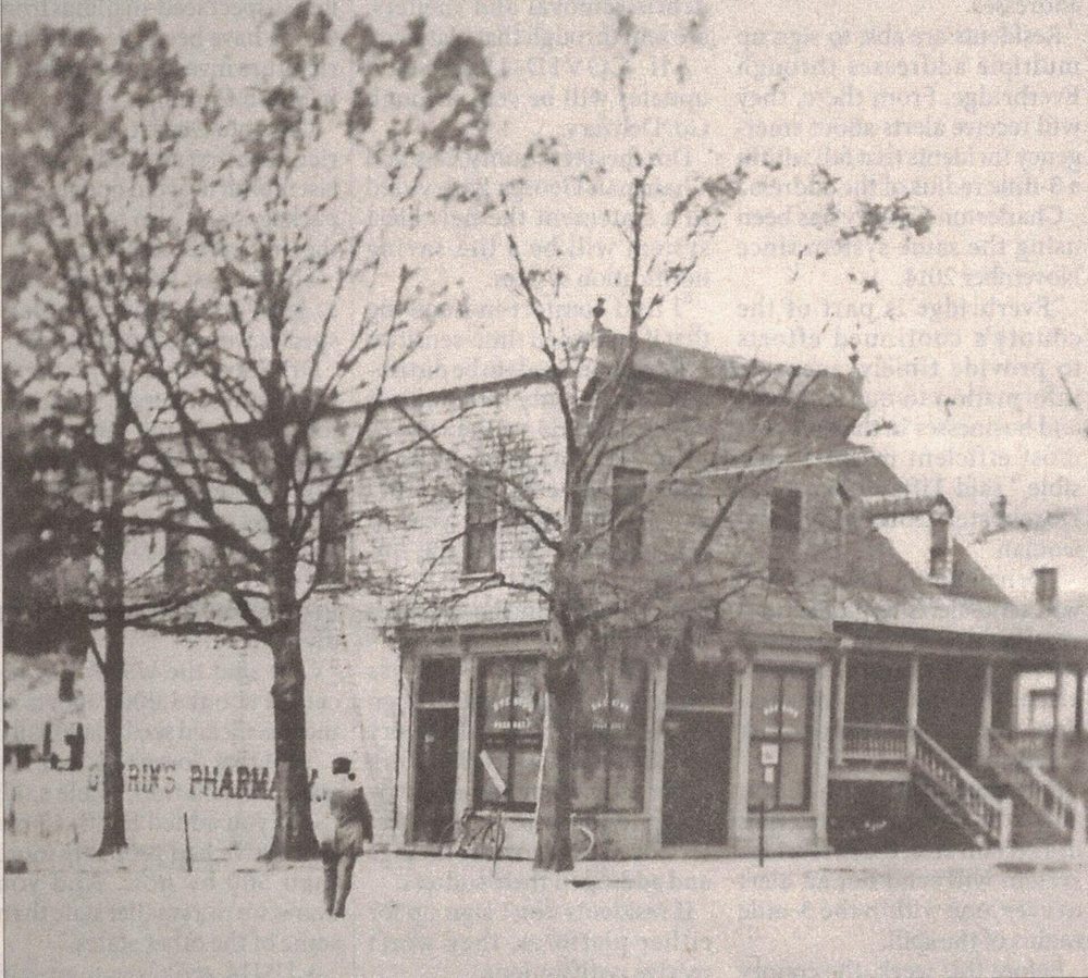
Guerin’s Pharmacy before its brick front
The two-storey frame corner building at the south end of the west side, “Guerin’s Pharmacy” painted on the wall, a bicycle leaning on the shopfront. Both the 1895 and 1902 maps mark “Drugs” on this corner lot.
- 1908 – mid-1930s
Nothing found
No photograph of the square from these years was found online. A local blog cites a 1916 view showing Model T cars and a horse and buggy, but the image is no longer online. The 1923 map below is the only record located.
- June 1923
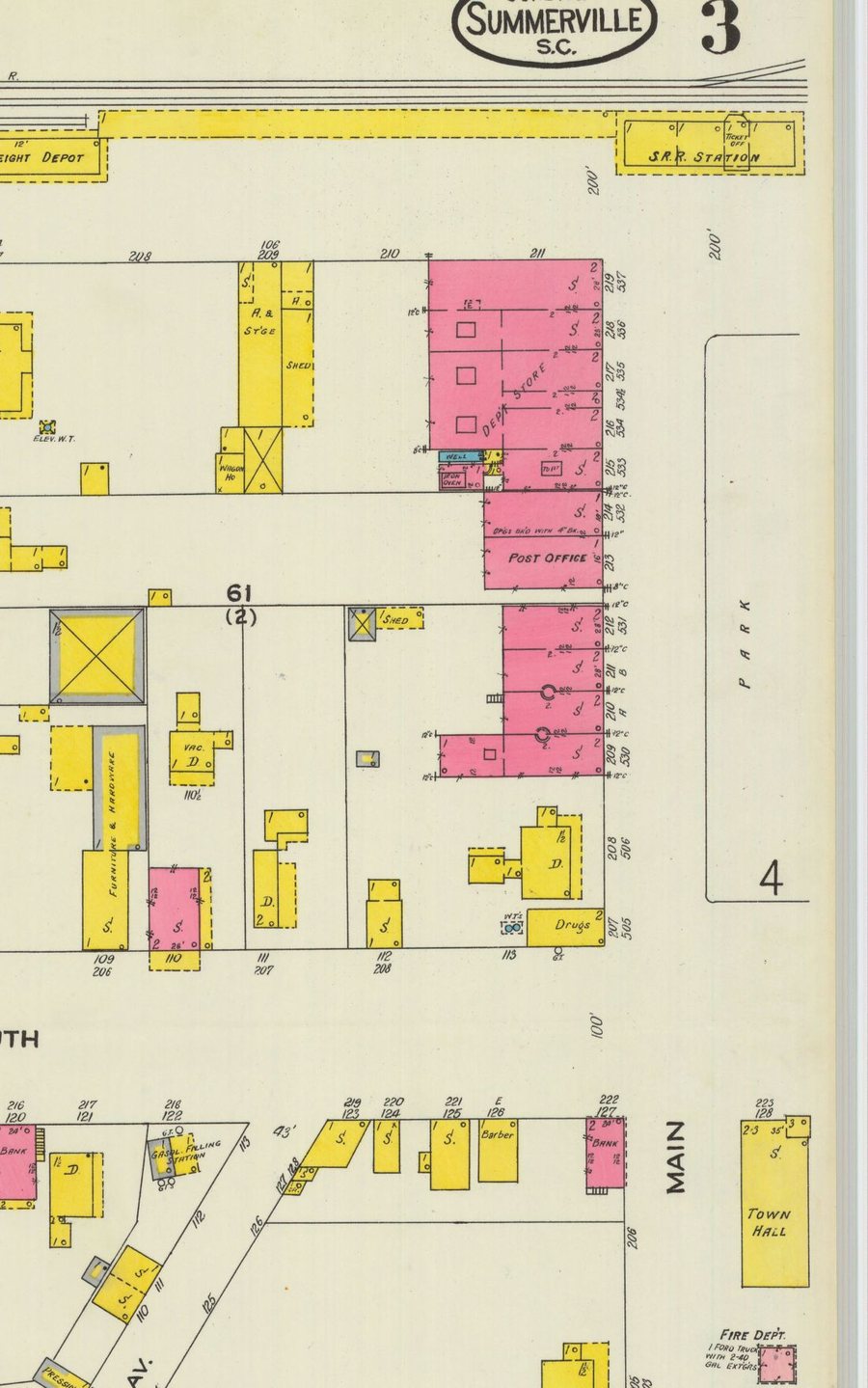
Fire-insurance map: station, freight depot, post office
The space is still labelled “Park.” The station at the north end is now joined by a long platform to a separate freight depot. The west-side brick row holds a department store and the post office. A fire department building with one Ford truck stands beside Town Hall.
1930s – 1960s
Station at one end, Town Hall at the other
For half a century the square had the same bookends: the Southern Railway station to the north and the towered Town Hall to the south. Both came down in the 1960s. Passenger service ended on October 26, 1962.
- Late 1930s – 1940s
Postcard: Southern Railway Station
The station that closed the north end of the square from about 1902: brick and shingle, a hipped roof with a half-timbered dormer, three chimneys, a deep canopy and a “Summerville” station board. Visit Summerville attributes it to architect Frank Milburn.
- c. 1940
The theatre facing the square
The brick theatre front at 133 South Main with its arched upper window and canopy marquee. The building later became the James F. Dean Theatre. Only a very small copy is online.
- March 1947
Centennial Parade passes Town Hall
Trucks and a crowd in the street in front of the old Town Hall, seen from a rooftop. Parked cars fill the ground around it, and the “Summerville Tea Pot” grocery fills Town Hall’s ground floor.
- 1940s – 1950s
The old Town Hall, north front
The three-storey stuccoed Town Hall that faced up the square: open belfry with its bell, flagpole, arched tower entrance, and the shop sign “Summerville Tea Pot – Groceries Meats Produce.” Sources date the building 1890, 1892 or 1893. It was demolished in the early to mid 1960s.
- 1948 – 1969
Nothing found
No street-level photograph, postcard, parade or Christmas scene from these years was found online. They are the years the square lost both bookends: the 1902 station was demolished after passenger service ended, and the towered Town Hall was replaced by the present one (built 1965 or completed by 1969; sources differ). Aerial photographs for 1955, 1957 and 1960 are on HistoricAerials.com, where they can be viewed but not copied.
1970 – 2018
The shaded lawn
With the station and old Town Hall gone, the square became an informal lawn under maturing live oaks, with shrub beds, scattered benches and parking pressed against both long sides. Town officials later said its last relandscaping before 2018 was a 1970 horticulture class project. The National Register nomination of 1976 calls it simply the “town square.”
- 1970
The small frame station that replaced the depot
Looking down the track: a plain white gable-roofed depot with a “Summerville” board. The big 1902 station is already gone. The usual account says the depot was demolished in the 1960s and leaves out this replacement.
Check Certainly the Summerville station; the record does not say where along the track it stood relative to the square.
- April 1974
The 1897 Sires building, with Cochran’s Shoes
The brick upper storey on the west side: a pressed-metal cornice and pediment lettered “Post Office,” boarded upper windows, and the “1897” date panel next door. Local commenters identify it as the brick block at the left of the 1906 photograph.
- April 1974
Contact sheet from the same roll
Twelve frames from the preservation survey. Three show the square’s frontage: the Sires building again (marked “Leave date”) and two frames of a corner drugstore with “Prescriptions” and “Bromo-Seltzer” in the window. The rest are houses and churches elsewhere in the district.
- August 1975Key view
The lawn, looking across to the theatre
The best 1970s view of the square itself. Open grass, a young magnolia and oak, one cobra-head street light, and angle-parked cars in front of Andrae’s Jewelers, a cleaners, Eva’s Restaurant, a beauty parlor and the cinema, whose marquee reads “Land That Time Forgot.” No fountain, stage or paving anywhere in frame.
- 1979
The frame station, still standing
A close view from across the track of the same small depot seen in 1970. No source found says when it was built or when it was removed.
Check Position relative to the square not documented.
- 1980 – 2008
Nothing found
No photograph of the square from these three decades was found online: nothing for Hurricane Hugo in 1989, nothing from the 1990s. Two dated changes fall in the gap. Susie Chisholm’s bronze “The Garden” was installed in April 2007, and Town Hall gained its bell tower, annex and parking garage the same year.
- October 2009
Scarecrows on the Square
The earliest photograph found that was taken inside the modern square. Two men carry a model locomotive across the grass past chrysanthemums and shrub beds, with the brick storefronts beyond the parked cars.
- November 30, 2010
Christmas tree lighting
The conical Christmas holly covered in coloured lights with a crowd around it, and the live-oak canopies traced in white lights behind. The newspaper re-ran this picture in 2012 and 2014.
- December 2010
Carolers under the lit oaks
The best picture found of the old layout in use: oaks wrapped in lights, benches, a green lamp post, and a reddish path curving through the grass.
- June 21, 2011
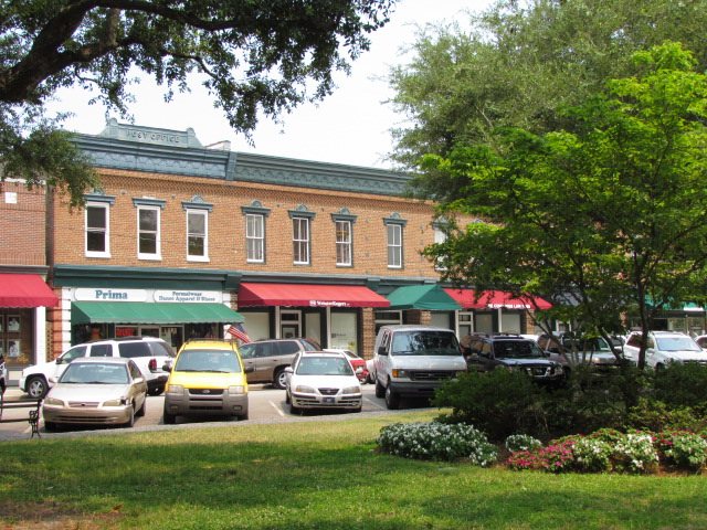
From the grass toward the shop row
Taken from the lawn, past a shrub bed and an overhanging oak limb, across the angle-parked cars to the two-storey brick block with red and green awnings. The only pre-renovation photograph found with a reusable licence.
Check The description says “Historic Downtown Summerville,” not the square by name; the grass, oak and angle parking match it.
- November 2014Key view
Down the length of the old square
The clearest daytime view before the rebuild: palmettos and a large live oak, lawn with a mulched shrub island, a bench, Main Street at left and parked cars at right. No fountain, pavilion, central walk or arch.
- April 11, 2018
The last view before the fences went up
A low masonry wall lettered “Hutchinson Square” between brick piers, clipped round shrubs, two benches on the grass and palmettos. Two months later the square closed for construction.

2015 – March 2019
The rebuild
The Hutchinson Square Master Plan of July 14, 2015 (Stantec, LS3P, Charleston Engineering and Cornerstone Surveying) set out to restore the central walk of the original park. Wildwood Contractors built it between June 2018 and February 2019. Three magnolias came out and three palms were moved; seven grand oaks, four Chinese elms and the Christmas holly were kept. Thousands of original street bricks found under the Little Main parking lot were reused. The ribbon was cut on March 1, 2019, at a reported cost of $2.3 million.
- July 14, 2015
Master plan: bird’s-eye view
The proposal from the Main Street and Doty Avenue corner: a gateway feature, a pavilion, a grand lawn, new walkways, a planted median on Main Street and parking kept on Little Main.
- July 14, 2015
Master plan: the central walk
The view the plan was built around, from the centre of the square north to the pavilion. The fountain as built is a single bowl, not the three tiers drawn here, and the pavilion roof is lower.
- June 3, 2018
“Coming Soon!” on the construction fence
A banner on the chain-link fence shows the plan’s rendering of the finished square, with a palmetto trunk and the old lawn behind it.
- July – October 2018
Nothing found
No photograph of the heavy construction months was found: the demolition, the wrapped oaks, or the original brick road uncovered under the Little Main parking lot. The Journal Scene reported the brick road on June 24, 2018, but its online article no longer carries a picture.
- November 27, 2018
The new fountain, running
The south part of the square reopened in time for the tree lighting. The fountain had been installed the day before. New benches and paving, a live oak and the Main Street storefronts behind.
- February 21, 2019
Sod goes down on the central lawn
A wide view down the square in its last week of work: a sod roller on the half-laid lawn, wheelbarrows, a lamp post lying on the ground waiting to be set, new borders, live oaks overhead.
- February 21, 2019
Capping a gateway pier
Workers on scaffolding set the cap on one of the brick piers that will carry the arch. The green-roofed pavilion is at right and the “Coming Soon” banner is still on the fence.
- February 26, 2019
The arch sign is lifted into place
A crane holds the green “Summerville” sign over the two piers while workers on a lift guide it down. A “Come celebrate with us!” banner hangs on the fence.
- February 2019
The Town’s own then-and-now
Top: the original “Summerville” arch over a dirt road through the pines. Bottom: the new sign being fixed to its piers. The original arch stood at the North Main Street entrance to town, not on the square; Visit Summerville dates it 1941, which is unverified.
- March 1, 2019
Ribbon-cutting day
The finished arch (“The Flower Town / Summerville / In the Pines”) and its brick pier against a blue sky, with the open pavilion behind. No photograph of the ceremony itself could be retrieved.
2019 – 2026
The square today
Photographs from 2019, 2020, 2021, 2024 and 2026 all show the same fountain, walks, planters, pavilion and arch. No report of construction at the square after March 2019 was found. What changes from picture to picture is the planting growing in and the seasonal dressing.
- June 2019
First summer: fountain plaza and pavilion
From beside the fountain basin: stone paving, brick seat-walls, benches, a live oak, and the pavilion at the north end across the new lawn.
- July 9, 2019
The gateway at sunset
The complete gateway from across Main Street: arch sign, pavilion, new corner planting and crosswalk sign, with the brick commercial block behind. The sign is double-sided. The back, facing the pavilion, reads “Let the pine be sacred.”
- December 2019
First tree lighting in the finished square
The Christmas holly, retained through the rebuild, in white lights with a star. It now ends the central walk at the Town Hall end.
- January 2020Key view
From the fountain down the central walk
Across the still water of the fountain bowl, south along the central walk between the oaks to the Christmas holly, with Town Hall beyond. It is the 1906 photograph’s axis, seen from the other end.
- December 2021
Snowflake arches over the walk
Illuminated snowflake frames arch over the central walk, small decorated trees line both sides, and the holly and Town Hall cupola close the view.
- 2023 or earlierKey view
The north end from above
The best single overview of the finished design: the arch and its piers at the Main and Doty corner, the green pavilion roof, the lawn and live oaks, Little Main parking and the long brick block beyond.
- May 2024
Five years on
The same view as June 2019, from the fountain plaza north to the pavilion and arch. The hardscape is unchanged; the planting now spills over the brick planters.
- August 2024
“The Garden” looking north
Susie Chisholm’s bronze of a seated woman, installed in 2007 and returned to a new bench pad in 2019. Beyond her: the brick-edged walk, the lawn, crape myrtles, and the pavilion and gateway.
- May 25, 2026
Memorial Day on the pavilion
An honour guard holds the flag on the pavilion stage, with the back of the arch and its “the pine … sacred” lettering behind them.
- June 2026
A concert, seen from the stage
The most recent view found: from behind the musicians, looking south over a seated crowd on the lawn under the oaks.
Dating a photograph of the square
If you turn up an undated print, these features narrow it quickly.
| What you can see | Date range |
|---|---|
| Gingerbread Victorian depot | 1880s to c. 1902 |
| Fence around the park, conical evergreens, sand streets | 1890s to 1900s |
| Brick Sires block on the west side | c. 1897 onward |
| Hip-roofed brick station at the north end | c. 1902 to 1960s |
| Three-storey Town Hall with belfry at the south end | c. 1890–93 to early 1960s |
| Present Town Hall, no bell tower | 1965–69 to 2006 |
| Small white frame depot by the tracks | by 1970 to at least 1979 |
| Lawn with shrub islands and palms, no fountain | 1970 to May 2018 |
| Seated bronze woman, “The Garden” | April 2007 onward |
| Construction fencing | June 2018 to Feb 2019 |
| Fountain | from Nov 26, 2018 |
| Arch sign and finished pavilion | from Feb 26, 2019 |
Where the missing pictures probably are
- Summerville Preservation Society. Holds the negatives for the April 1974 survey roll, which has frames of the square that were never printed.
- SC Department of Archives and History. Holds the August 1975 negative and the 1979 and 1984 building survey cards for 100 to 140 South Main.
- Summerville DREAM. Has worked downtown since 1992. Nothing from the 1990s is online from any source.
- Summerville Journal Scene and Post and Courier photo files. The likeliest home of Hurricane Hugo, the parades, the 2018 brick road and the 2019 ribbon-cutting.
- Summerville Dorchester Museum and Timrod Library. Neither has an online photo catalogue.
If you have a dated photograph of the square from one of those years, we would like to hear from you.
Sources
- Library of Congress, Detroit Publishing Co. Collection
- University of South Carolina, South Carolina Postcards
- University of South Carolina, Sanborn Fire Insurance Maps
- National Park Service, Summerville Historic District nomination photographs
- Lowcountry Digital Library, Charleston County Public Library
- Visit Summerville walking tour
- Town of Summerville, Hutchinson Square Master Plan (2015)
- Post and Courier, February 2019
- Live 5 News, March 1, 2019
Compiled October 2026 from sources open on the web. Dates marked as estimates are readings of the image, not archive dates. Created by the Larry Collett Consulting Group. Powered by Automation Captain and Data Clairity.